The majority of commissions are for custom illustrated maps that fulfil a specific brief.
A brief can be highly detailed or of a more general description, whatever
the nature of the brief further discussion by phone, email, or a meeting helps to define
requirements.
Pricing is established according to the usage of an image. As a guideline we use the Association
of Illustrators price structuring for the UK and Europe, For the USA we use a similar set of guidelines
published by the Guild of Graphic Artists.
In the first instance, a quotation would be for a single use licence and beyond this further uses can be
negotiated. Artwork is quoted on a fixed fee basis, enabling the client to understand what the final cost
will be.

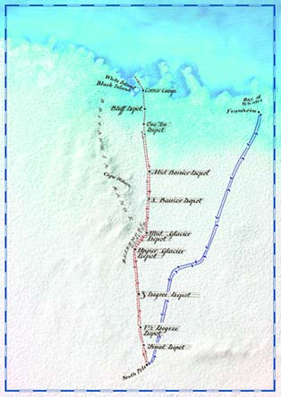
Clients often remark on the large range of approaches and styles in the Hand Made Maps portfolio.
This is due to several factors. Firstly, that style is seen as the coming together of content and
technique. This can be seen in the image below produced for BBC History magazine and illustrating
Scott's Antarctic Expedition. The artwork was made from table salt and sprayed with matt acrylic medium,
then the sea was added using turquoise dye that soaked the salt coastline and then travelled by capillary
action. This mimicked the effect of sea water and and ice as seen from above. The artwork was then
photographed from above, the hand lettering done on an overlay.
This leads to the second principle, the emulation of the surface of the earth. Over the last 100 years, the
photography of the earth's surface has produced an infinite variety of beautiful images, all governed by
the chance effect of the elements interacting. It is these effects that we try to incorporate in the work if
possible. A visual description of the particular location through the use of surface texture and colour.
This can be seen particularly in the TransRe Mural. (click for link)
Thirdly, an illustrated map artwork is a combination of three traditional skills, map-making, objective
drawing and hand-lettering. The work is based in these traditional techniques applied in a new way for
each particular brief - hence the variety within the pieces shown on the site.
Having produced artwork for the last 30+ years, we would like to express thanks to all those who have offered
work to Hand Made Maps. Without creative commissioning, none of this could have happened. The best results
come from a meeting of minds where creative sparks are allowed to happen. So thank you to the Art Directors/Editors/
Buyers/Private Clients (click for link) who have commissioned Hand Made Maps, for playing an important role in what can be
seen across the site.